Emre BORAZAN
  • About
  • Portfolio
  • Experience
  • Contact
Emre BORAZAN

Emre BORAZAN

Geomatics Engineer & Software Developer

Get In Touch Learn More

Professional Summary

GIS Analyst and Software Developer with over four years of experience in GIS applications, spatial analysis, geospatial automation, and web application development. Proficient in Esri platforms, ArcGIS Pro and ArcGIS Online with strong coding skills in Python and JavaScript. Experienced with spatial databases (PostgreSQL/PostGIS, MySQL) and advanced geoprocessing tasks such as raster analysis, network modeling, flood risk assessment, and 3D GIS Modelling. Expertise in managing enterprise geospatial systems, conducting spatial analysis, automating GIS workflows, and performing ETL functions using FME. Skilled in identifying client needs, delivering tailored geospatial solutions, and managing long-term customer relationships to support business growth.

Email emre@emreborazan.com emreborzn@gmail.com
Location Denver, Colorado

Portfolio Projects

Image
Hydrological Mapping of Stream Networks

This project identifies and visualizes stream networks on the European side of Istanbul using DEM-based hydrological analysis. By mapping flow directions and accumulations, it reveals the region’s drainage patterns and supports flood management and watershed planning.This analysis supports environmental planning, flood risk assessment, and watershed management initiatives in the area. Click to see more details...

Image
Spatial Prediction of Ozone Concentration in California

This project aims to model and predict ozone concentration levels across California using spatial interpolation techniques such as Ordinary Kriging. By leveraging monitoring station data and applying geostatistical methods, the study visualizes the spatial distribution of ozone, identifies pollution hotspots, and supports environmental decision-making related to air quality management. Click to see more details...

Image
Flood Risk Analysis Project

Aim of the Project is that predict and determine the possible effects areas of a flood event, it is important to consider different types of spatial data and analysis techniques.Water areas and waterways are rasterized to apply proximity analyses. Click to see more details...

Image
Watershed Boundaries in the European Side of Istanbul

This project delineates the watershed boundaries on the European side of Istanbul using DEM-based hydrological analysis. By identifying 15 distinct watershed areas, the study supports flood management, water resource planning, and environmental assessment in the region. Click to see more details...

Image
Best Route Analysis Project

In this project that has been aimed the driver who is responsible for the distribution should start from the flour depot, visit each restaurant, bakery and cafe, and return to the starting point. To find the best effective route for the distribution of flour, this projected aim to find the route plan by using appropriate network analysis and report the total distance that has to be driven. Analyses has obtained in ArcGIS Pro software with Network Analyses technic.

Image
Best Bicycle Route Project

Bicycle route project was carried out for the Sariyer district of Istanbul province using open source data. Literature research was conducted to determine the bicycle path determination criteria and analyses were carried out using the analytical hierarchy method. Analysis was carried out by weighting the determined criteria. As a result of the analysis, the current bicycle routes appear to support the analysis results.

Image
3D GIS Modelling of Civil Engineering Faculty Building Project

Utilizing FME to convert building plans into GIS-compatible formats and integrated with geospatial databases. Conducting advanced spatial analyses and visualizations using ArcGIS and QGIS to support data-driven decision-making in campus planning and management.

Image
Healtcare Service Coverage in Istanbul

The analysis provides a realistic visualization of healthcare accessibility, considering actual travel paths rather than simple Euclidean buffers. This helps identify well-served regions as well as potential accessibility gaps, which are critical for urban planning and healthcare service distribution.
Click to see more details...

Image
Metrobus Based Healtcare Accessibility

This map aims to evaluate healthcare accessibility from metrobus stations across Istanbul by integrating public transit networks with hospital locations. Using OD cost matrix analysis, accessibility scores were calculated based on network distances, highlighting how transit connectivity influences healthcare service reachability. Click to see more details...

Image
Spatial Relationship Between Population, Land Use, and Transportation Using GWR

This project applies Geographically Weighted Regression (GWR) to explore the spatial relationship between population distribution, land use, and transportation networks. Click to see more details...

Image
3D GIS Modelling Lodging Building of ITU Maslak Campus

The method used in this study is to extract 3D data from current architectural projects using CAD files in the DWG data format, following to specific requirements.

Image
3D GIS Modelling Campus of Istanbul Technical University

Three-Dimensional Campus modelling was created in order to improve campus building planning, navigation,and management.

Work Experience

Oct 2023 – Present Aspen Tech Team
GIS Analyst / Software Developer
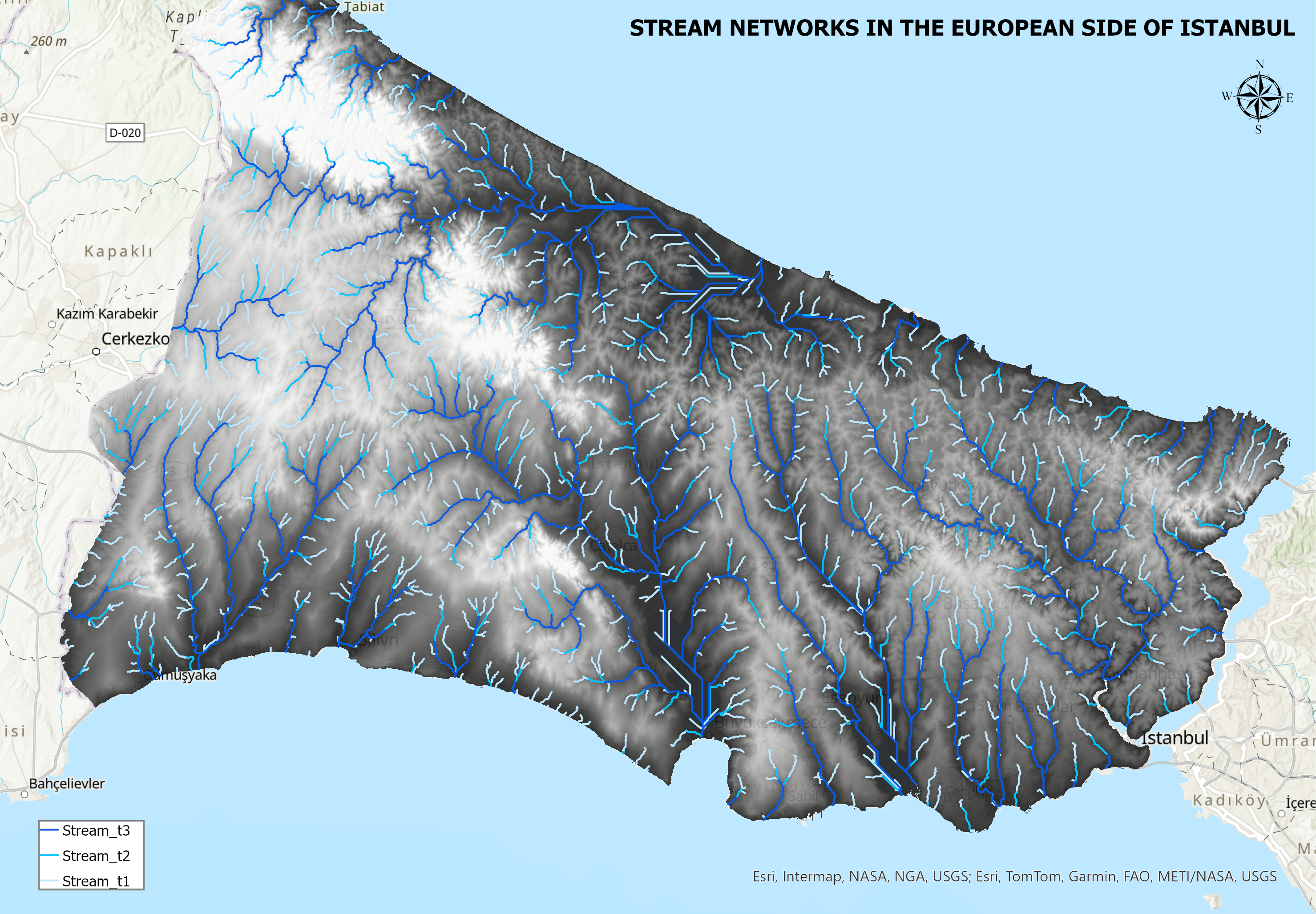
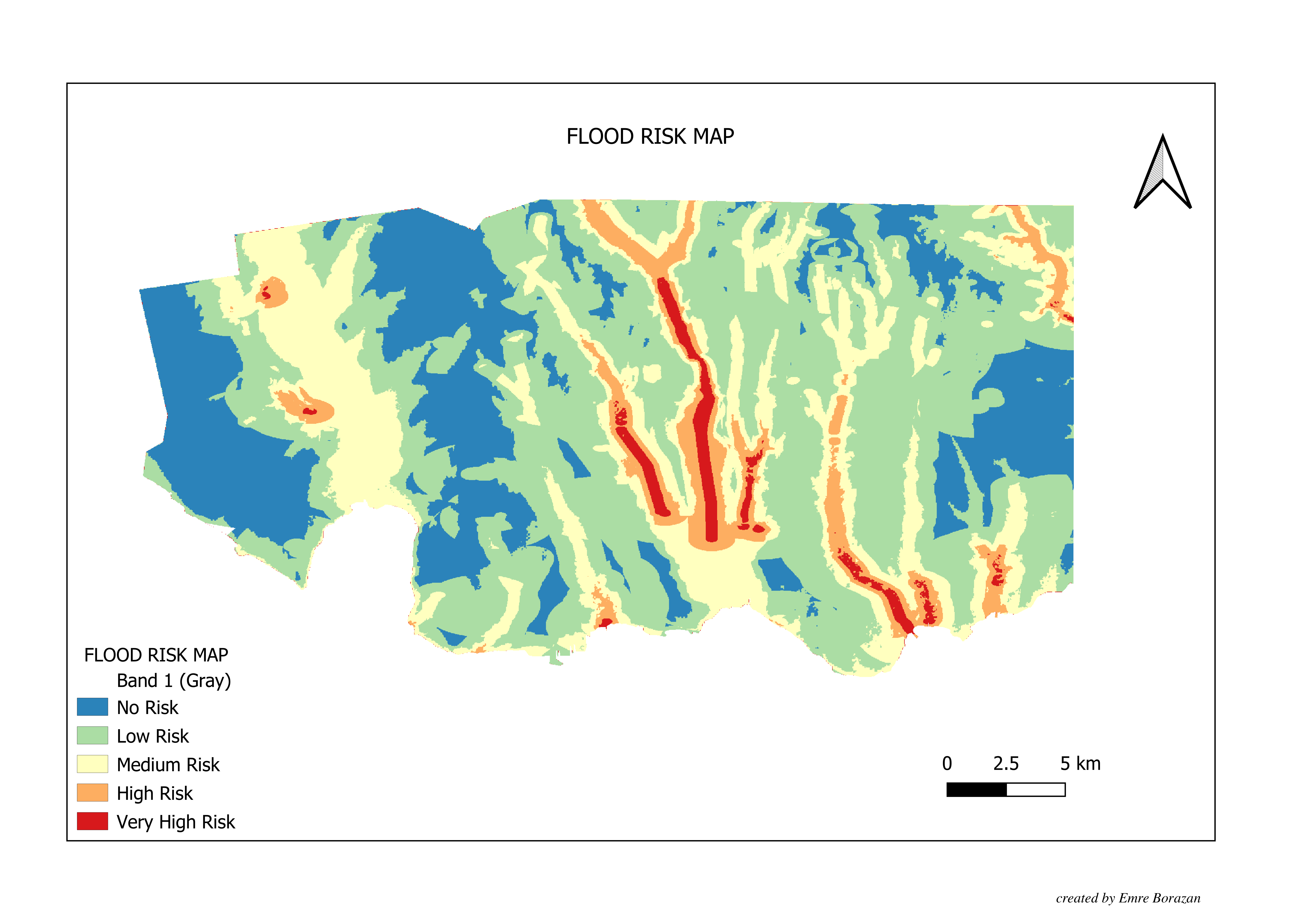
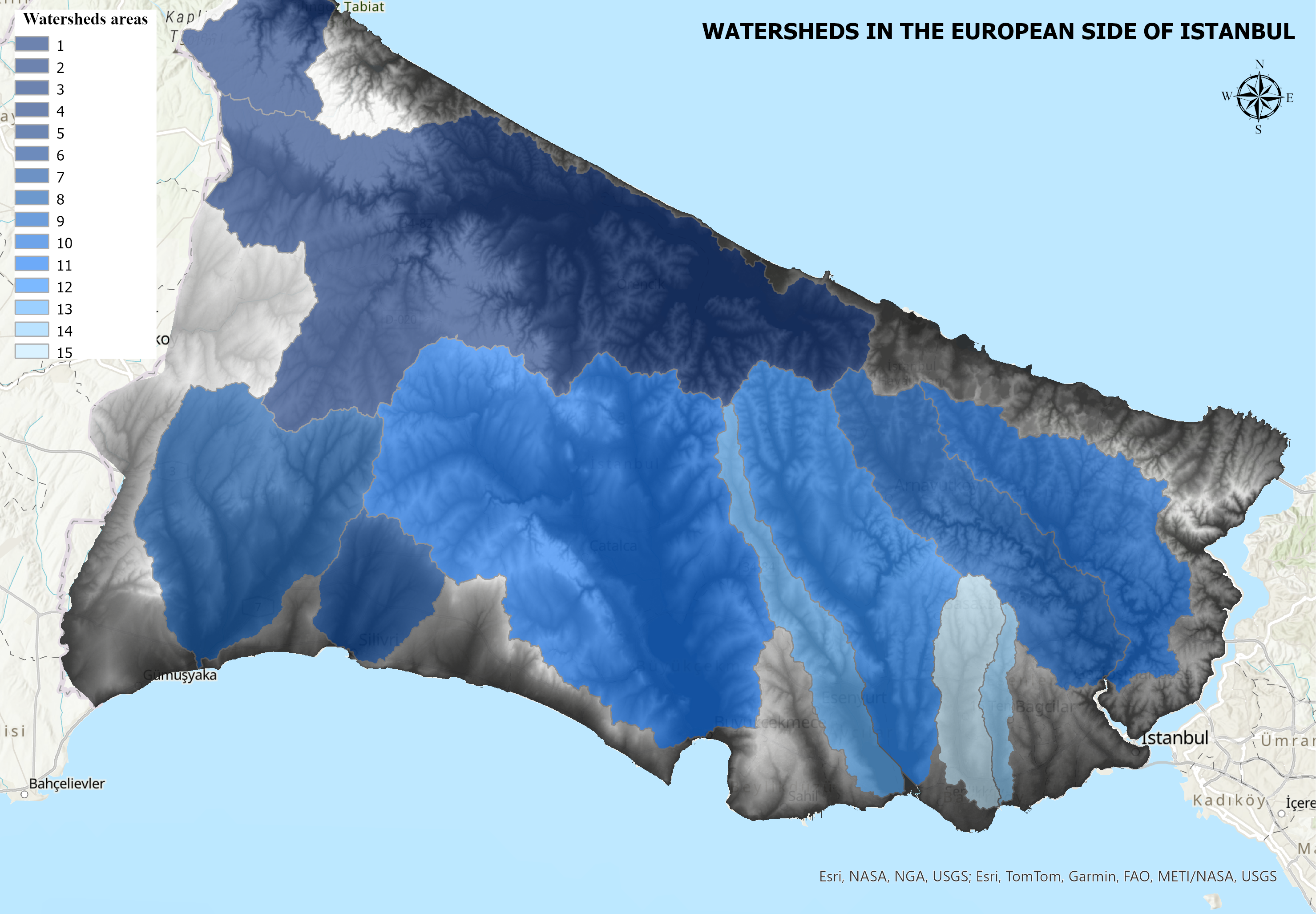
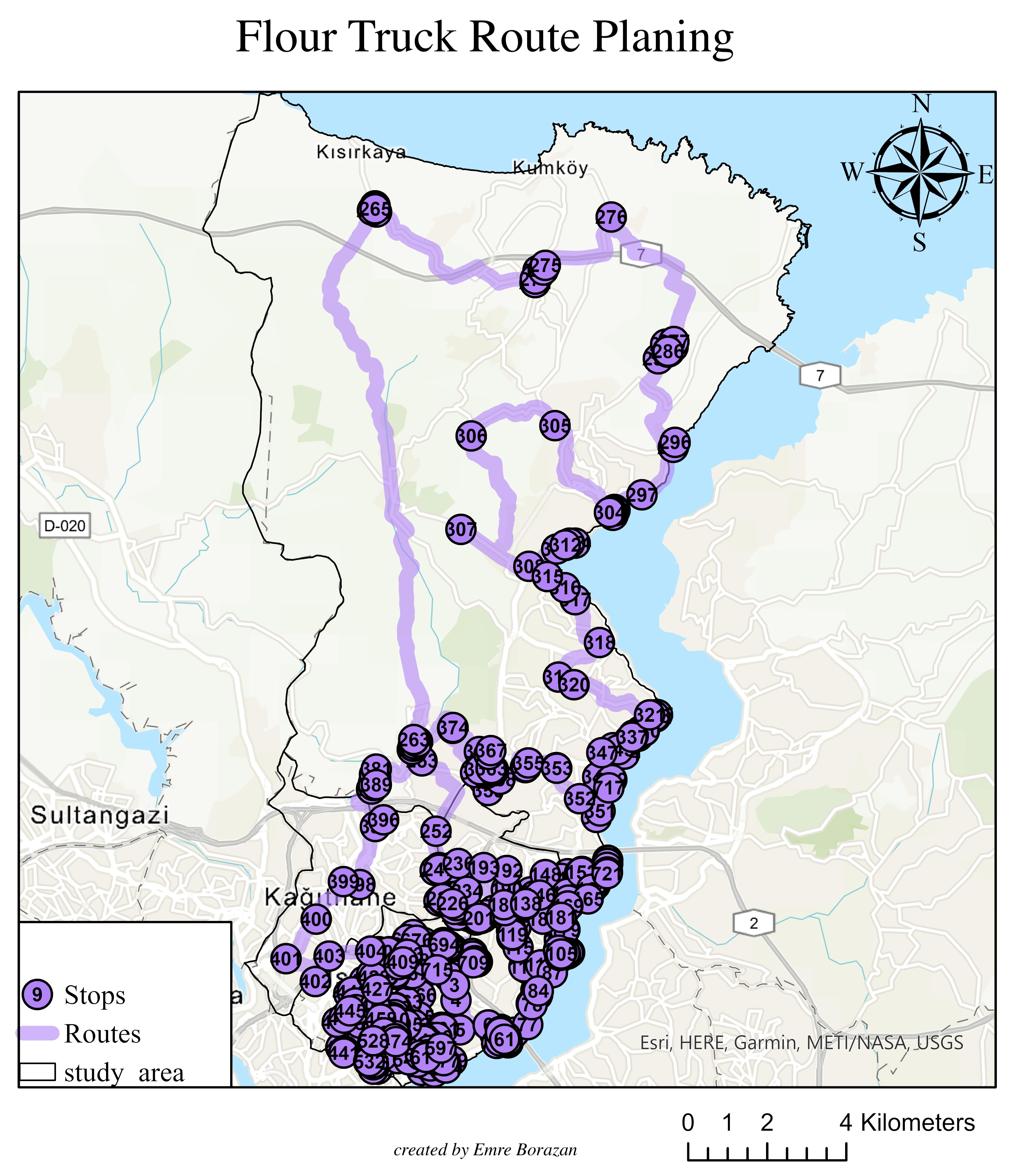
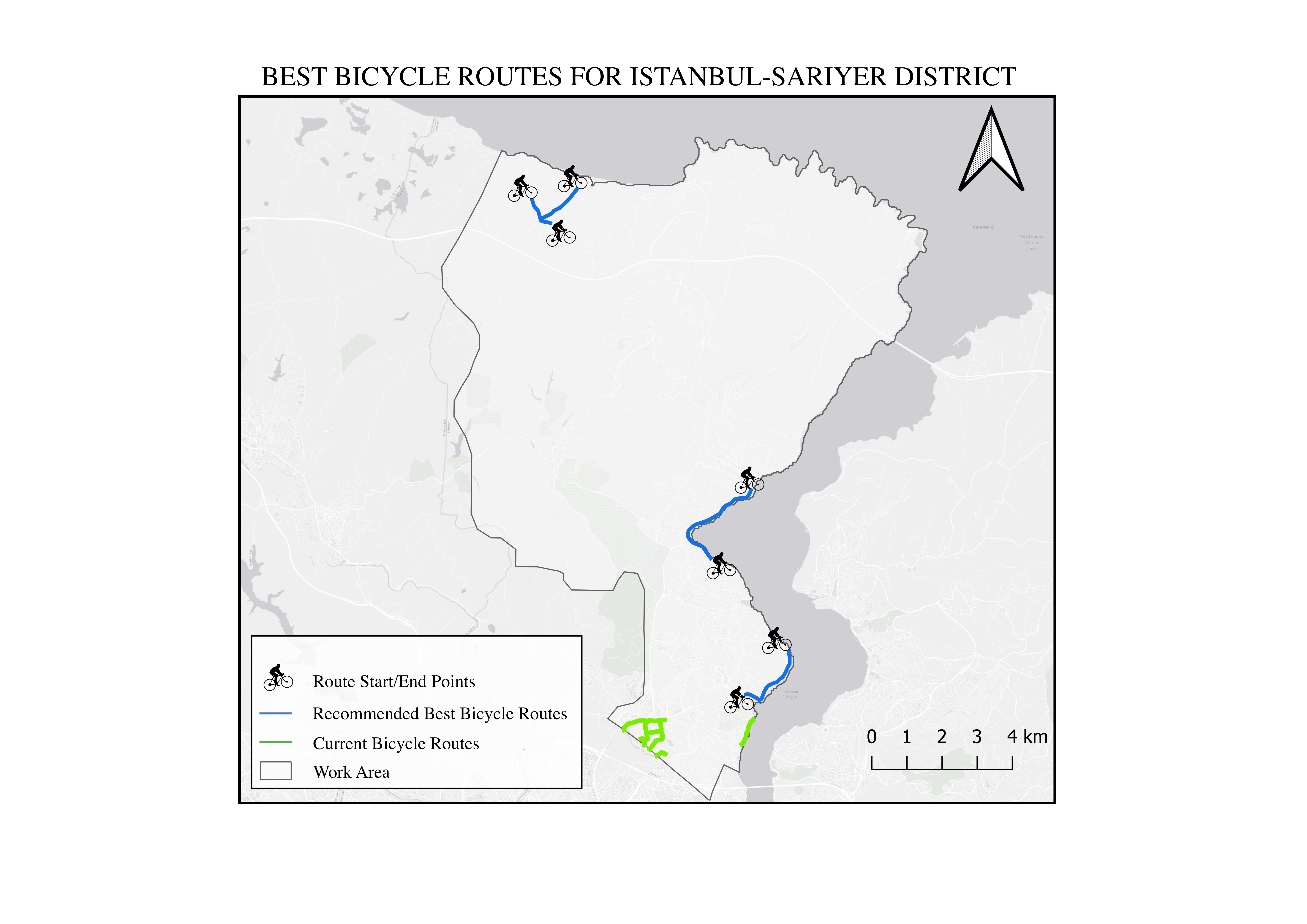
  • Designed spatial databases and executed spatial analyses in ArcGIS Pro to support infrastructure planning and operational decision-making.
  • Designed and implemented GIS databases with PostgreSQL and SQL, enhancing spatial data accessibility and reducing query times by 30%.
  • Diagnosed and troubleshot complex IT problems, providing timely assistance and guidance.
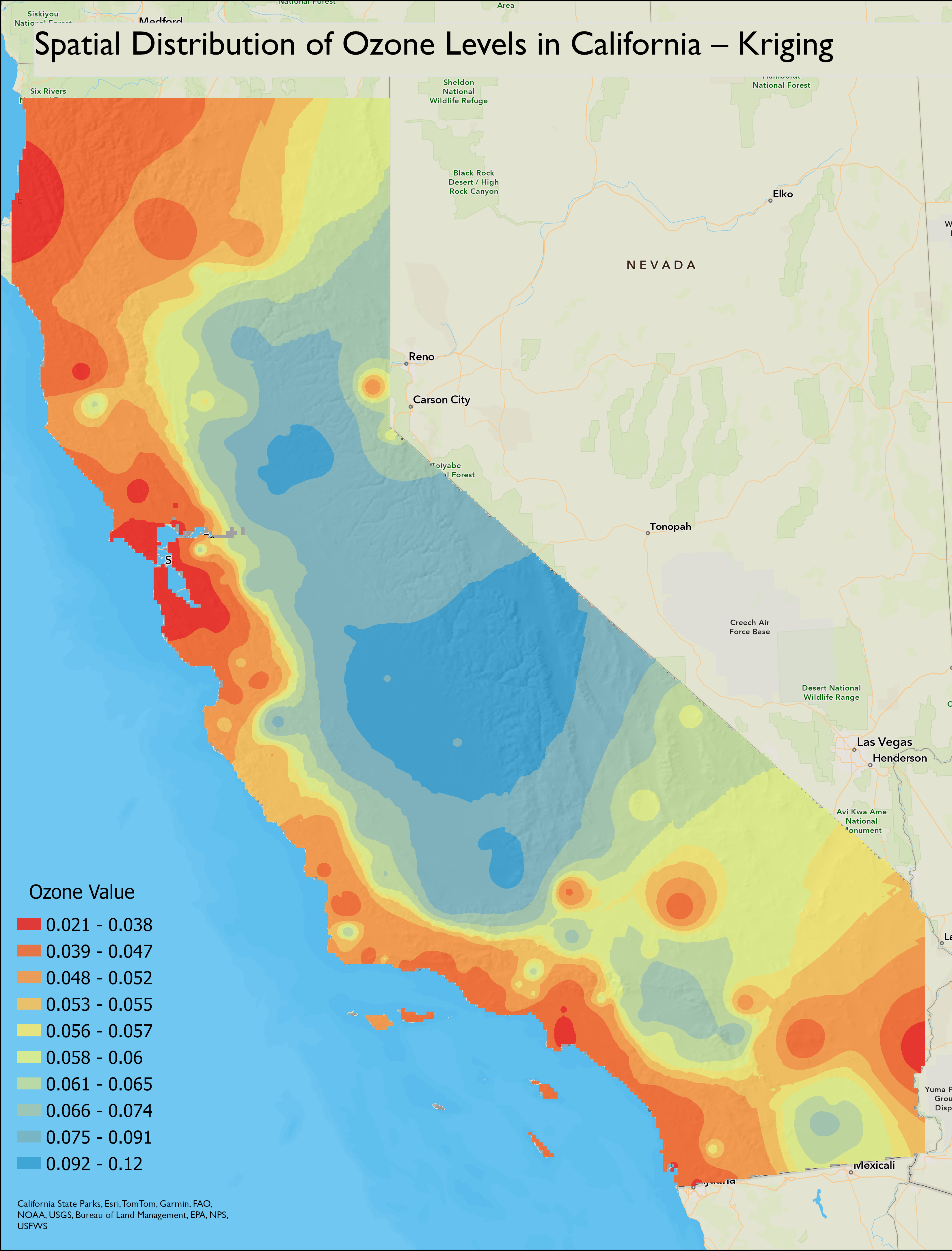
  • Conducted spatial analysis and developed mapping solutions using ArcGIS and Esri Tools to support organizational goals.
  • Streamlined troubleshooting and support processes for end-users, reducing resolution times by 35%.
Sep 2022 – Jun 2023 Istanbul Technical University
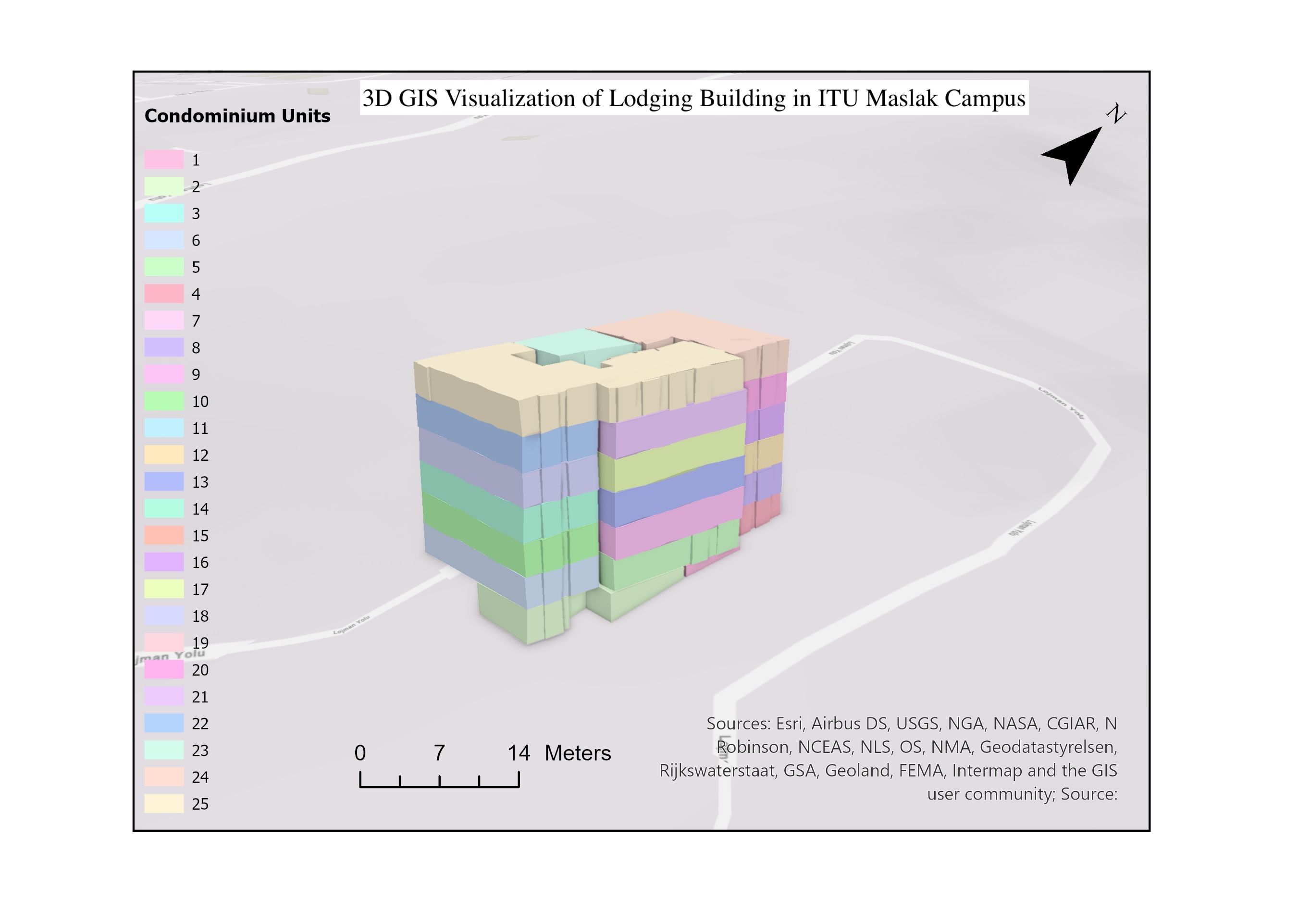
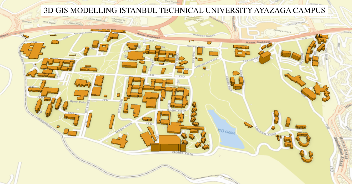
Undergraduate Researcher — GIS Project
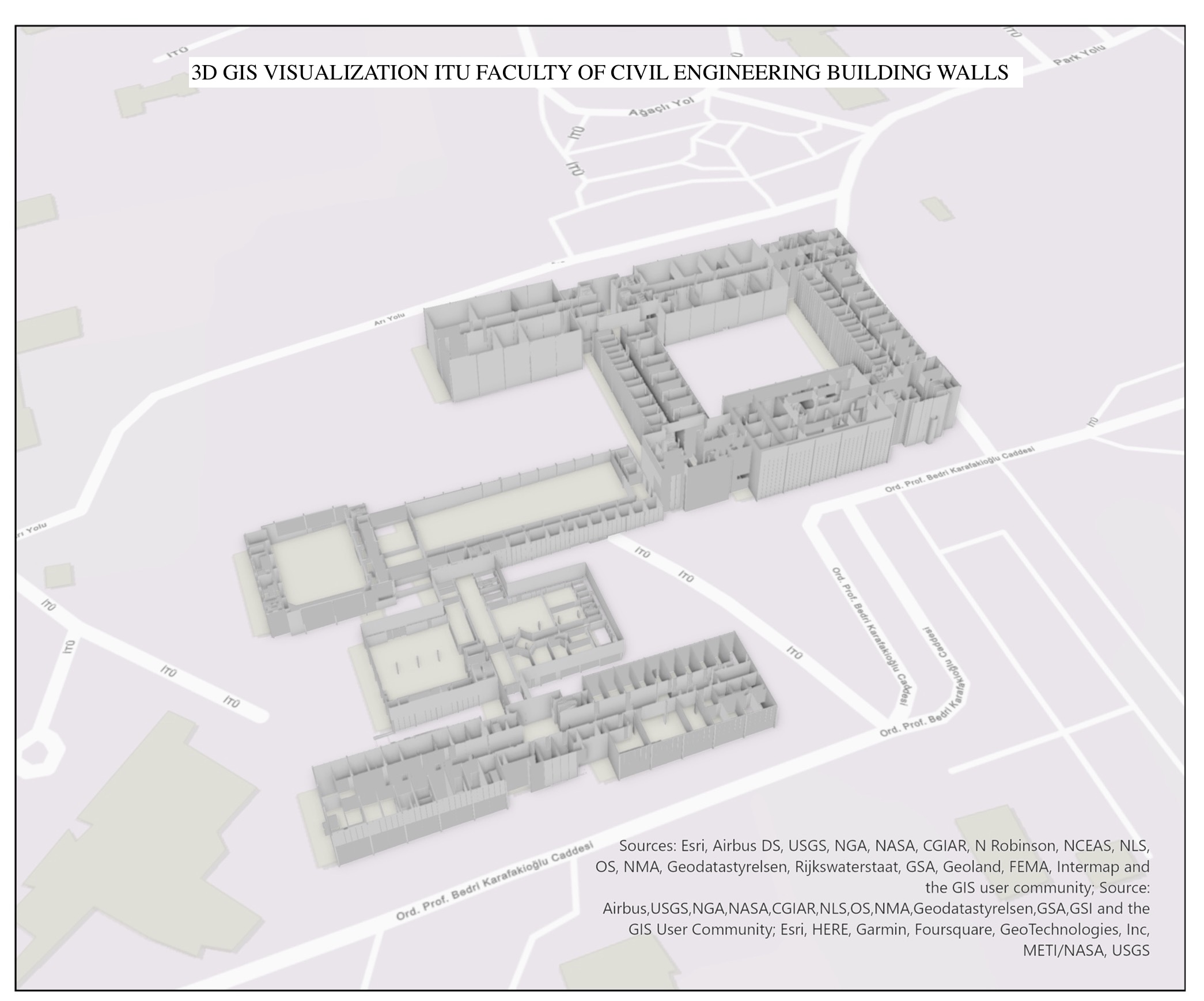
  • Developed three-dimensional campus modelling to improve building planning, navigation, and management.
  • Extracted 3D data from architectural projects using CAD files in DWG format following specific requirements.
  • Utilized ArcGIS and QGIS for spatial analysis throughout the investigation.
  • Obtained CityGML format using FME Workbench and FME Data Inspector tools.
  • Conducted research on 3D modelling by converting shape-based file formats to CityGML. Aimed to decrease expenses up to 45%.
Jan 2023 – Mar 2023 POILabs
GIS Analyst
  • Delivered highly detailed indoor maps for navigation projects using QGIS and PostGIS, increasing spatial data accuracy by 25%.
  • Enhanced spatial database quality through optimized management in PostgreSQL, reducing data processing time by 20%.
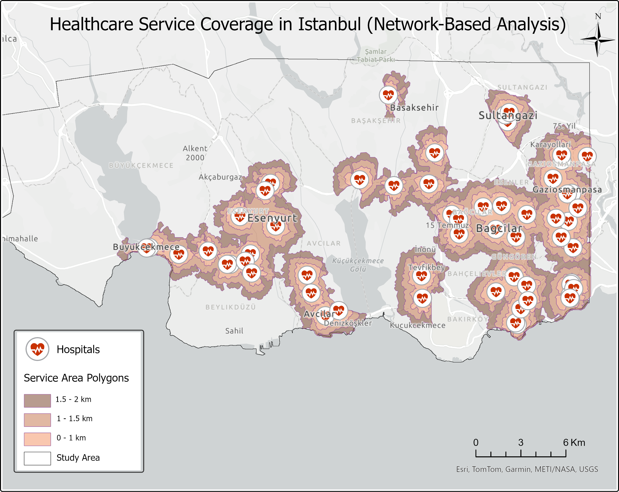
  • Analyzed geospatial data from airports to extract valuable insights and patterns.
  • Performed spatial analyses using Python and GIS libraries such as GDAL and SAGA.
  • Created thematic maps with QGIS and presented results to management.
Sep 2020 – Jan 2021 ER Mapping & Engineering
Geomatics Engineer
  • Conducted precise land surveys for factories and gas pipelines using GPS and GIS technologies, improving data accuracy.
  • Collaborated on allotment-amalgamation processes, ensuring efficient land use and management.
  • Optimized land use processes by leveraging GIS and GPS technologies, reducing spatial data processing time by 25%.
  • Provided detailed spatial data for pipelines and utility systems, increasing infrastructure planning efficiency by 20%.

Education

Istanbul Technical University
Bachelor's Degree in Geomatics Engineering

Get In Touch

Location Denver, Colorado
Email emre@emreborazan.com
Emre BORAZAN © 2025 All rights reserved.